
Tagudin is my first scheduled stop while I was doing the North Luzon Loop starting from Laguna. This town has a rich history and played a major role in the Battle of Bessang Pass. Important, yes. But unique, not really. The Philippines is riddled with historic sites after all.

But don’t write off Tagudin from your list just yet. There’s a lot to see here and it is home to the first sundials constructed in 1841 by Father Juan Sorolla. OK, so the padre built a time-telling device that works only when the sun is shining, what’s the big deal?

The first sundials in the Philippines.
The big deal my friend is in the awesomeness how this fixed structures rely on Geography, Astronomy, and Mathematics. This things don’t just get built “just like that”, there’s Science behind it. I remember when I was a kid, a cartoon showed a sundial that has 12 stones arranged just like in a regular watch with a stick (well..) sticking up in the middle (just like this image). Like clockwork (pun intended), the shadow of the stick pointed to the stones to tell the correct time. You can imagine how puzzled I was when I tried it out on the front yard. LOL!

I was praying for the clouds to clear the sky and Rizal was like, “Seryoso ka?“
Sundials have different forms or types depending on the location. Since our planet is round (fine! oblate spheroid. NERD!), we get different amount of sunlight and the sun’s rays strike us at different angles at different locations. So a sundial’s design (horizontal, vertical, polar, equatorial, etc..) should match where it is located. We fall under equatorial.
We can better to visualize how the sundial is positioned relative to the sun and the equator with an actual illustration. Thankfully, I purchased a mini sundial from the souvenir shop. I don’t have a globe, but I have a helmet so let’s improvise. Pretend that the helmet is Earth and Philippines (from a 100-peso bill) is located just above the equator (red line). The sundial should be positioned in such a way that its face (where the shadow falls) or dial plate should be parallel to the equator and the gnomon is parallel to the Earth’s axis. The gnomon(NO mon) is the part of a sundial that casts the shadow. It’s ancient Greek meaning “indicator”. The gnomon is pointing to the North Celestial Pole. Anything placed parallel to the equator will cast a shadow that changes 15 degrees each hour.

An improvised illustration how the sundial is positioned. I did my part being creative, now please be imaginative :p
This is the reason why the sundial in front of the town hall is positioned as it is – without care where Rizal is facing or how the plant boxes is in order with the street or walls of the town hall. The gnomon points North and is parallel to the Earth’s axis and the dial plate is parallel to the equator. But just how do you determine how to “parallel-ize” them with imaginary lines?

Me: Sundial, harap sa kanan, ‘RAP!
Sundial: ^%$#@$!
That’s where our favorite (Urgghh!) Math comes in. Tagudin is located at 16.9°N latitude, therefore the gnomon is inclined at an angle of 16.9 degrees and the dial plate is inclined at a 73.1 degree complementary angle. For more brain-bleeding activity, please see the illustration from SCSA below:
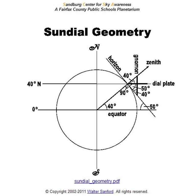
In this example, the sundial is located 40 degrees North. We are somewhere around 17 degrees North
The sundial has latitude-longitude coordinates written on its side. Most sundials include that information. That’s the fundamental aspect of a sundial, its location. When I was there, I didn’t think much of the accuracy of the coordinates because it looked right. Yes, I am familiar with our lat-long coordinates because I grew up in Bicol pinpointing the eye of the storm from the data broadcasted over the transistor radio. :p Learn more about Coordinates here. When I got back from the trip, I plotted the coordinates in Google Maps and surprisingly, it pointed to the Pacific!! Try it yourself with iTouchMap here.

The coordinates written on the sundials is 670 kms off the mark. Continental drift couldn’t have moved us that far in under 172 years.
I checked and re-checked and it really is way off the mark. If we carefully study the original sundial, we can see that these information are engraved to it. It must’ve been hard for Father Sorolla to engrave these markings but the characters looked pretty clear and consistent.

Dates on the front and back indicate the duration which side is to be used when.
The major discrepancy with the coordinates is with the longitude’s degrees. At the equator, 1 degree is equal to111 kms. It decreases as you go farther from the equator since all the longitudes come together at the poles. So, if the “126 degrees” engraved there is really “120 degrees”, that points somewhere in the Cordillera mountains near Bakun and Manyakan. The 670-km variance is now just 36 kms. In 1841, that might be a reasonable variance.
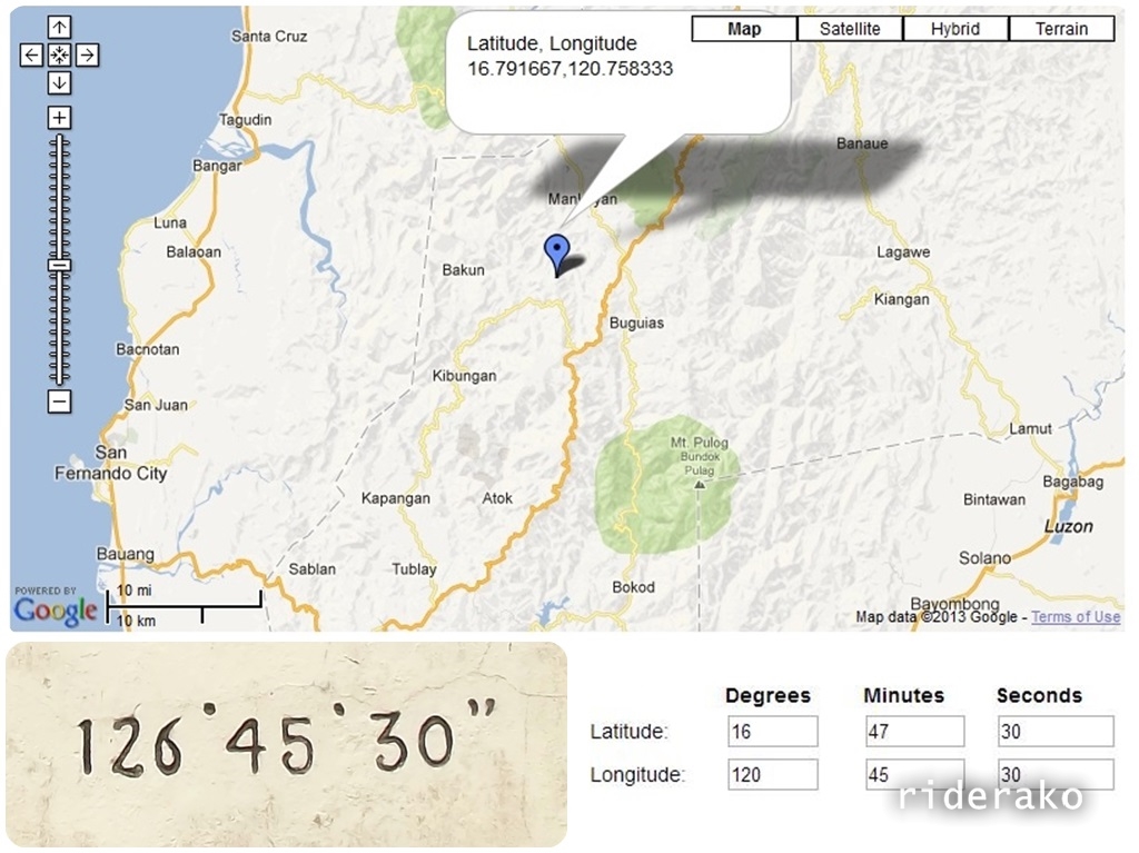
The blue marker shows the coordinates if the longitude degrees is 120 instead of 126.

Top picture is the longitude coordinates painted on the replica. Pictures below it are from the original. Notice the consistency with the numbers 6 and 0.
But I won’t stop with that theory. Notice that the “number 6” in “126 degrees” and in “16 degrees” is similar with each other. Just like how the “number 0” is consistent in both “30 seconds”. I think that typographical error happened even before the engraving. Maybe an ink blot or a smudge gave that zero a horn that made it a six. Maybe a crease or a crumple. I don’t know. Tagudin’s Tourism Officer Louie, said they don’t have any data but will investigate. Can you help us? Please let us know in the comments.


We really appreciate your visit kabayan to our loved hometown
You’re welcome, Neo! I had to shAre what I learned..
my head is bleeding to understand the theory hehe 🙂
i really appreciate and learn from your blog about my hometown. It’s a shame on me you seemed to know better about my hometown than i do
Your blog is very informative. Thanks for sharing Doms. I missed to see these sun dials on 2 of my Ilocos trips. I will find them when i get back